| Highway 26 Corridor Study - Watertown |
Highway 26 Corridor Study Home - Purpose - Meetings - Maps of the Watertown, Jefferson and Milton bypasses |
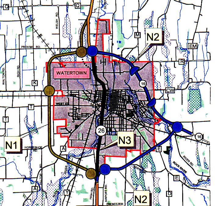
| Watertown alternatives - Segment 3, North Segment
Three alternatives are under consideration for the Watertown area: Alternative N1 west of the city, Alternative N2 east of the city, and one alternative through the city of Watertown on existing alignment, Alternative N3. These alternatives are those presented at the June 1999 public information meetings, with minor refinements. The North segment begins at Baneck Lane about a mile north of IH 94. Two more lanes are proposed to be added between Baneck Lane and the City of Watertown, primarily on the east side of the existing road. Alternative N1 is the near-west alternative and would provide a connection to Highways 16 and 19 with an interchange on the north side of the city of Watertown. It provides a four lane rural divided roadway, with an operating speed of least 55 miles per hour, with access at three locations. Interchanges are proposed on the north and south sides of the city of Watertown, and at STH 19. Bndges separating traffic are proposed at CTH Y and CTH A, both railroad crossings and several town roads. An interchange at CTH A is under consideration. One benefit to this alternative is that it connects STH 16, STH 19 and STH 26. Alternative N2 is the near-east alternative and would utilize the current Highway 16 bypass. This would require that Highway 16 be improved to a freeway. It provides a four lane rural divided roadway, with an operating speed of at least 55 miles per hour. This altemative would provide interchanges at the south and north edge of the city of Watertown and with STH 16. Bndges separating traffic would be proposed at CTH X and CTH E, the railroad crossing and several town roads. This alternative would coincide with the existing STH 16 bypass, which would be reconstructed to a four lane rural divided roadway and would eliminate all access except at interchanges. Half diamond interchanges with connecting frontage roads would be proposed for CTH R, also known as North Fourth Street, and Oak Hill Road. Alternative N3 provides for a four lane divided urban street through the city of Watertown on existing alignment. This through-Watertown altemative would provide a posted speed limit of 45 miles per hour. The access would be limited with several signalized intersections, meaning that the operating speed would be approximately 40 miles per hour. This alternative would probably require that buildings on one side of the street or the other be removed. A variation of the through-Watertown alternative that closely follows the Union Pacific Railroad corridor between Bemard Street and Spaulding Street is also being studied. Infommation about this altemative is available today. North of Watertown, two more lanes are proposed to be added, primarily on the east side, although to avoid relocations, there will be several areas where the new lanes are proposed to be added to the west side. The study ends at the STH 60 east intersection. Click the map for a larger, more detailed view.
Study Committee Jeffrey L. Haas Russell Cooper Bruce Haukom Judy Weter Craig Kunkel Donald Reese Theodore Ziebell Richard Gimler George Stuehler Harry Dopke Joseph Radocay, P.E. Harvey Radtke Bob Krystyniak Dean Perlick Chester Caine Robert A. Sindelar, P.E. William Nass Carol J. Wollin John Hanson Neale R. Jones John Liechty Dr. Robert Long LeRoy K. Schultz Greg David Augie Tietz Larry Mistele, Chairperson Jim Oeth, P.E. Anne Monks Kimberly Johnson, P.E. Kate Sullivan |
This goJefferson.com Web presentation of these public documents is Copyright 2004 Syndesis Corporation. |