| Highway 26 Corridor Study - Jefferson |
Highway 26 Corridor Study Home - Purpose - Meetings - Maps of the Watertown, Jefferson and Milton bypasses |
| Jefferson alternatives - Segment 2, Central Segment
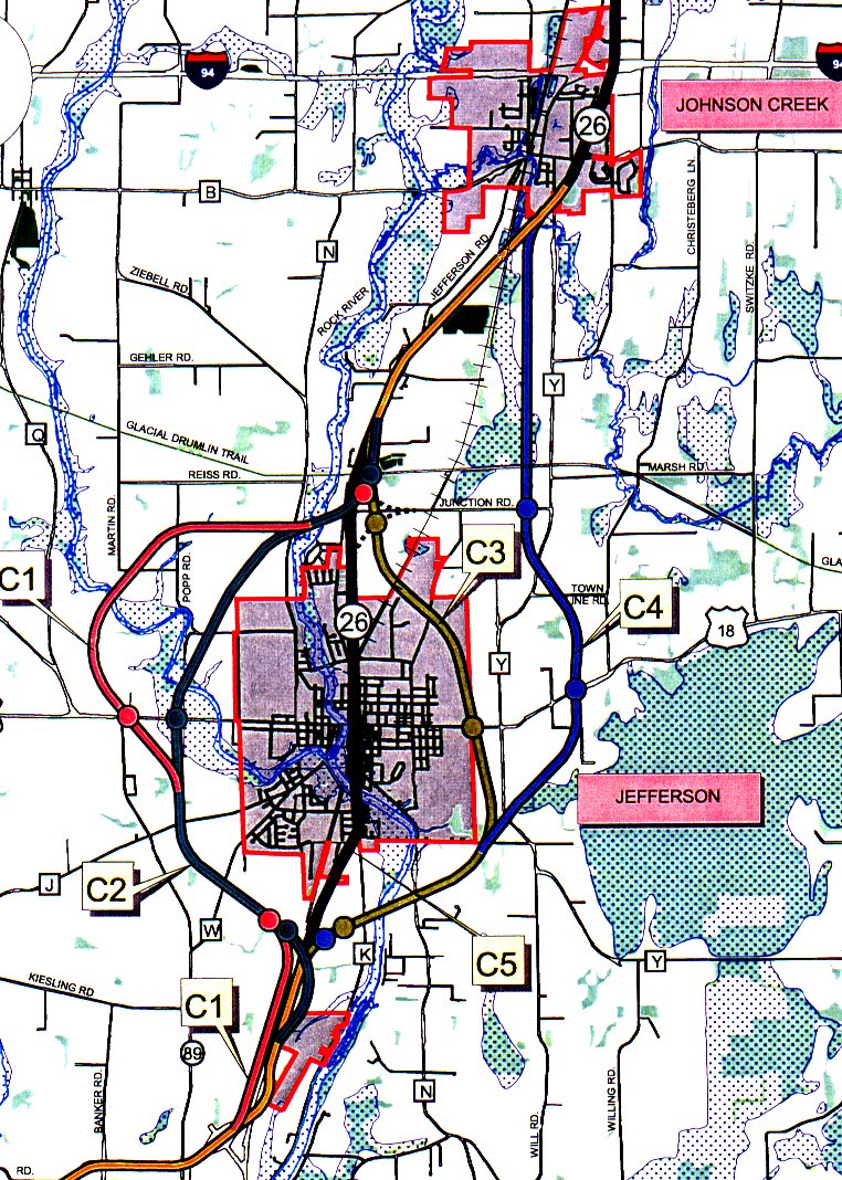
The Central segment begins at the Business 26 interchange on the south side of the city of Fort Atkinson. The other two lanes that were previously planned for the Fort Atkinson bypass would be added. Bndges would be built to carry Banker Road and Hoard Road over STH 26. Jefferson area alternatives to be studied further include two options west of the city of Jefferson (C1 and C2), two options east of the city (C3 and C4) and option C5 through the downtown area of the City of Jefferson on the existing roadway. Alternative C1 Alternative C1 is now the most westerly alternative and was modified to revise the interchange location with Highway 18 so it is located west of the Crawfish River and the associated floodplains. It provides a four lane rural divided roadway, with an operating speed of at least 55 miles per hour, with access at three locations. From the Business 26 interchange on the north side of the city of Fort Atkinson this altemative parallels the railroad tracks on the west side between the two cities. Interchanges are proposed at the south and north sides of the City of Jefferson and at USH 18. Bridges separating traffic are proposed at CTH W, CTH J, CTH N, and several local roads. Alternative C2 Alternative C2 is the near westerly alternative and was modified to revise the interchange location with Highway 18 so it is located west of the existing Crawfish River bridge. It provides a four lane rural divided roadway, with an operating speed of at least 55 miles per hour, with access at three locations. Interchanges are proposed at the same locations on the south and north sides of the City of Jefferson as with Alternativc C1. An interchange at USH 18 is also proposed, but this interchange is just west of the existing Crawfish River bridge. Bndges separating traffic are proposed at existing STH 26, the railroad, CTH W, CTH J, CTH N, and several local roads. Alternative C3 Alternative C3 is the near-east alternative. This alternative was refined to provide a partial cloverleaf interchange at Highway 18 with all ramp movements on the north side to allow St. Coletta residents to safely walk along the south side of Highway 18 without having to cross any intersections. It provides a four lane rural divided roadway, with an operating speed of at least 55 mph. Interchanges are proposed at the south and north sides of the City of Jefferson and at USH 18. The interchange at USH 18 is designed with all ramp movements on the north side to allow the St. Coletta residents to safely walk on the south side of USH 18 without having to cross any interchange intersections. Bridges separating traffic are proposed at CTH K, CTH N, the railroad and several local roads. Alternative C4 Alternative C4 is the most easterly alternative and was modified to coincide with Alternative C3 until the southeast corner of Jefferson where it continues east and north. This alternative avoids direct impacts to the St. Coletta facilities. It provides a four lane rural divided roadway, with an operating speed of 55 mph. This alternative coincides with Altemative C3, diverging near Vogel Road. This alternative avoids direct impacts to St. Coletta's facilities. Three interchanges are proposed with this altemative . The interchange on the south side of the City of Jefferson is proposed at the same location as with Altemative C3. An interchange at USH 18 is also proposed, but this interchange would be located east of St. Coletta, just skirting the Jefferson Marsh. An interchange with Junction Road is proposed to provide access to the north side of the city of Jefferson. This altemative would match back into STH 26 at the CTH Y intersection in the village of Johnson Creek. Bndges separating traffic are proposed at CTH K, CTH N, both locations with CTH Y and several local roads. Alternative C5 Alternatlve C5 provides for a four lane divided urban street through the city of Jefferson on existing alignment. This through-Jefferson altemative would provide a posted speed limit of 45 miles per hour. Within the city, access would be limited with several street closures and several signalized intersections, meaning that the operating speed would be approximately 40 miles per hour. This altemative would probably require that buildings on one side of the street or the other be removed. Once STH 26 is back on the existing alignment, two more lanes are proposed to be added. Planned improvements will begin in 2001 in the Johnson Creek area and will be completed in 2002. These improvements will add two more lanes and provide signalized intersections with CTH Y, CTH B, the IH 94 ramps and at the entrance to the Johnson Creek Outlet Mall. Click the map for a larger, more detailed view.
Study Committee Jeffrey L. Haas Bruce Haukom Paul Swart Jae Ames John Wilmet Jeff Woods, P.E. Arnold Brawders David Schornack Dan Ludwig, P.E. Sue Johann Harold Bockmann Richard Schmidt Dick and Dianne Sharratt Charles Marks Kate Herro Edward Dettmers Donald Reese Judy Weter Craig Kunkel Kevin Burow David Olsen James Oeth, P.E. Anne Monks Kimberly Johnson, P.E. Kate Sullivan |
This goJefferson.com Web presentation of these public documents is Copyright 2004 Syndesis Corporation. |